

For asset owners, long‑term portfolio viability depends on understanding how climate and extreme weather risks may impact performance across regions and over time. To date, these risks have been difficult to quantify consistently, limiting the ability to assess potential financial exposure.
MeteoLens addresses this gap by enabling owners to incorporate long‑term climate risk into project evaluation and financing decisions. With this insight, owners can more effectively risk‑adjust their portfolios—reducing exposure to correlated losses and building more resilient growth strategies.
V4.1 and MeteoLens together support more informed global decision‑making across development, financing and long‑term asset management by addressing both historical performance and forward‑looking climate risk.
https://fast.wistia.com/player.jshttps://fast.wistia.com/embed/fsadjcfani.jswistia-player[media-id=’fsadjcfani’]:not(:defined) { background: center / contain no-repeat url(‘https://fast.wistia.com/embed/medias/fsadjcfani/swatch’); display: block; filter: blur(5px); padding-top:56.25%; }
document.addEventListener(“DOMContentLoaded”, function() {
// Add Wistia media-id from above code
const mediaId = “fsadjcfani”;
const wistiaContainer = document.querySelector(‘wistia-player[media-id=”‘ + mediaId + ‘”]’);
if (wistiaContainer) {
const observerOptions = {
root: null,
threshold: 0.05
};
const observer = new IntersectionObserver((entries, observer) => {
entries.forEach(entry => {
if (entry.isIntersecting) {
checkAndAddFallback(entry.target);
observer.unobserve(entry.target); // Optional: Stop observing after checking once
}
});
}, observerOptions);
observer.observe(wistiaContainer);
}
function checkAndAddFallback(container) {
if (!container.shadowRoot || container.shadowRoot.childNodes.length === 0) {
if (!container.querySelector(‘.browser-fallback-message’)) {
const fallbackMsg = document.createElement(‘div’);
fallbackMsg.className = ‘browser-fallback-message’;
// Update fallback message text. Keep similar HTML tags.
fallbackMsg.innerHTML = ‘
It looks like your browser settings blocked this video from loading.
No problem—you can open the video directly using this link.
‘;
container.appendChild(fallbackMsg);
container.classList.add(‘fallback-container’);
}
}
}
});
What’s new in SolarAnywhere Data Version 4.1
SolarAnywhere V4.1 builds on the V4.0 irradiance model with significant updates that result in reduced model uncertainty. This release reflects the continued investment by the Clean Power Research® team to deliver the highest quality datasets, validation metrics and transparent uncertainty characterization.
Key highlights include:
- Implemented an advanced parallax correction algorithm to account for sun angle and cloud height, improving pixel‑to‑location mapping and irradiance realism
- Integrated the highest‑resolution native satellite imagery across Europe, Africa and the continental United States (CONUS), improving local variability and model accuracy
- Added Meteosat Third Generation (MTG) satellite data, expanding use of next‑generation geostationary observations across Europe and Africa
- Incorporated 2025 into long‑average products, including Typical Year (TGY/TDY) datasets
Improving irradiance accuracy through parallax correction in V4.1
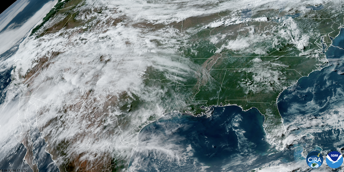
Satellite‑derived solar resource models must account for geometric distortions that occur when cloud height and satellite viewing angle introduce spatial misalignment—commonly referred to as parallax error. If left uncorrected, parallax can cause cloud features to be assigned to the wrong surface location, introducing additional error into irradiance estimates.
In SolarAnywhere V4.1, enhanced parallax correction techniques are applied to more accurately align cloud features with their true geographic location. The approach considers satellite viewing geometry, sun angle and cloud height to determine where a cloud must be located to cast a shadow at a given point on the ground. From the satellite’s perspective, this enables identification of the appropriate image pixel that represents the actual conditions at that location.
The video in Figure 1 illustrates the conceptual geometry of the parallax effect and its correction, illustrating how cloud position is adjusted based on satellite viewing angle and cloud height. This correction allows satellite image pixels to be re‑mapped so that the pixel used in the irradiance model corresponds to the true conditions at the surface.
https://fast.wistia.com/player.jshttps://fast.wistia.com/embed/a4demy37xv.jswistia-player[media-id=’a4demy37xv’]:not(:defined) { background: center / contain no-repeat url(‘https://fast.wistia.com/embed/medias/a4demy37xv/swatch’); display: block; filter: blur(5px); padding-top:56.25%; }
document.addEventListener(“DOMContentLoaded”, function() {
// Add Wistia media-id from above code
const mediaId = “a4demy37xv”;
const wistiaContainer = document.querySelector(‘wistia-player[media-id=”‘ + mediaId + ‘”]’);
if (wistiaContainer) {
const observerOptions = {
root: null,
threshold: 0.05
};
const observer = new IntersectionObserver((entries, observer) => {
entries.forEach(entry => {
if (entry.isIntersecting) {
checkAndAddFallback(entry.target);
observer.unobserve(entry.target); // Optional: Stop observing after checking once
}
});
}, observerOptions);
observer.observe(wistiaContainer);
}
function checkAndAddFallback(container) {
if (!container.shadowRoot || container.shadowRoot.childNodes.length === 0) {
if (!container.querySelector(‘.browser-fallback-message’)) {
const fallbackMsg = document.createElement(‘div’);
fallbackMsg.className = ‘browser-fallback-message’;
// Update fallback message text. Keep similar HTML tags.
fallbackMsg.innerHTML = ‘
It looks like your browser settings blocked this video from loading.
No problem—you can open the video directly using this link.
‘;
container.appendChild(fallbackMsg);
container.classList.add(‘fallback-container’);
}
}
}
});
https://fast.wistia.com/player.jshttps://fast.wistia.com/embed/dc57wsn9sa.jswistia-player[media-id=’dc57wsn9sa’]:not(:defined) { background: center / contain no-repeat url(‘https://fast.wistia.com/embed/medias/dc57wsn9sa/swatch’); display: block; filter: blur(5px); padding-top:56.25%; }
document.addEventListener(“DOMContentLoaded”, function() {
// Add Wistia media-id from above code
const mediaId = “dc57wsn9sa”;
const wistiaContainer = document.querySelector(‘wistia-player[media-id=”‘ + mediaId + ‘”]’);
if (wistiaContainer) {
const observerOptions = {
root: null,
threshold: 0.05
};
const observer = new IntersectionObserver((entries, observer) => {
entries.forEach(entry => {
if (entry.isIntersecting) {
checkAndAddFallback(entry.target);
observer.unobserve(entry.target); // Optional: Stop observing after checking once
}
});
}, observerOptions);
observer.observe(wistiaContainer);
}
function checkAndAddFallback(container) {
if (!container.shadowRoot || container.shadowRoot.childNodes.length === 0) {
if (!container.querySelector(‘.browser-fallback-message’)) {
const fallbackMsg = document.createElement(‘div’);
fallbackMsg.className = ‘browser-fallback-message’;
// Update fallback message text. Keep similar HTML tags.
fallbackMsg.innerHTML = ‘
It looks like your browser settings blocked this video from loading.
No problem—you can open the video directly using this link.
‘;
container.appendChild(fallbackMsg);
container.classList.add(‘fallback-container’);
}
}
}
});
Updated V4.1 validation and uncertainty characterization
As part of the release, Clean Power Research has published an updated SolarAnywhere V4.1 Validation Whitepaper, continuing our commitment to global transparency as a bankable solar resource data provider.
The V4.1 irradiance model demonstrates consistent improvements in accuracy, with reduced annual, daily and hourly bias, and reduced variability of bias across nearly all regions. The validation evaluates model performance against a global network of high‑quality ground measurement stations, with a focus on characterizing bias and uncertainty across a broad range of geographies, climates, seasons and operating conditions. Standard industry validation metrics—including mean bias error (MBE), mean absolute error (MAE) and root mean square error (RMSE)—are used to provide clear insight into model performance and uncertainty.
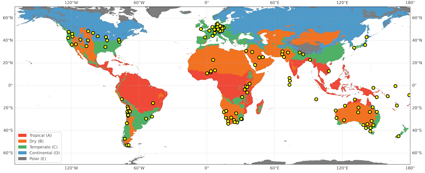
The V4.1 validation also includes expanded analysis by climate type, enabling stakeholders to better understand not only how uncertainty varies regionally, but how it differs across climate regimes. Figure 3 illustrates the diversity of climates within each geography.
Introducing MeteoLens: Historical and forward looking climate insights
While historical data remains foundational to solar resource assessment, long‑lived energy assets increasingly benefit from a broader analytical view that considers both historical performance and potential future climate‑driven risk. The new MeteoLens™ license expands SolarAnywhere capabilities in two key ways:
- Historical smoke-related irradiance impacts and extended historical summary datasets – Enhanced historical datasets that quantify the impact of wildfire smoke on solar resource, and irradiance and weather history extended back to 1960 enable analysis of long‑term meteorological trends. Project finance has traditionally relied on 30‑year irradiance histories that may not capture emerging risks from extreme weather. MeteoLens enables owners to better assess risk from severe loss scenarios (e.g., debt default), as well as improve shorter‑term financial predictability, such as monthly profit and loss.
- Scenario-based climate projections – CMIP6‑aligned climate projection datasets, covering multiple Shared Socioeconomic Pathway (SSP) scenarios through 2099, extend SolarAnywhere beyond historical and short‑term forecast analysis to evaluate potential future conditions. This matters because system performance is driven by environmental conditions. With MeteoLens, development and performance engineers can more reliably predict energy yield under future climate scenarios, including the impact of temperature‑driven derates on modules and battery operation.
MeteoLens is structured as a per‑location license upgrade to existing SolarAnywhere historical data licenses. This allows users to combine bankable historical solar resource and weather data with additional insights into past performance impacts and potential future conditions. Together, these capabilities build on SolarAnywhere’s foundation as a globally trusted partner for solar resource intelligence to support:
- More confident yield assessments
- Improved evaluation of climate‑driven risk over an asset’s expected lifetime
- A better understanding of how historical weather and extreme events have influenced performance
Hourly CMIP6 aligned climate projections through 2099
MeteoLens provides access to location‑specific climate projections aligned with the CMIP6 Shared Socioeconomic Pathways (SSPs), extending SolarAnywhere insights through the end of the century. These datasets cover key meteorological drivers relevant to solar performance, including irradiance, temperature, wind, relative humidity and precipitation.
The projections are based on outputs from the Max Planck Institute Earth System Model (MPI-ESM1.2), with native daily climate variables transformed into hourly time series using proprietary Clean Power Research machine-learning techniques. By preserving daily variable totals and long-term trends, these algorithms generate realistic sub-daily variability useful for PV analysis workflows that leverage hourly or 8760-format inputs. These datasets support:
- Long-term yield and hardware (module, BESS) degradation analysis
- Climate‑aware PV performance modeling
- Sensitivity studies aligned with emerging disclosure and risk‑assessment frameworks
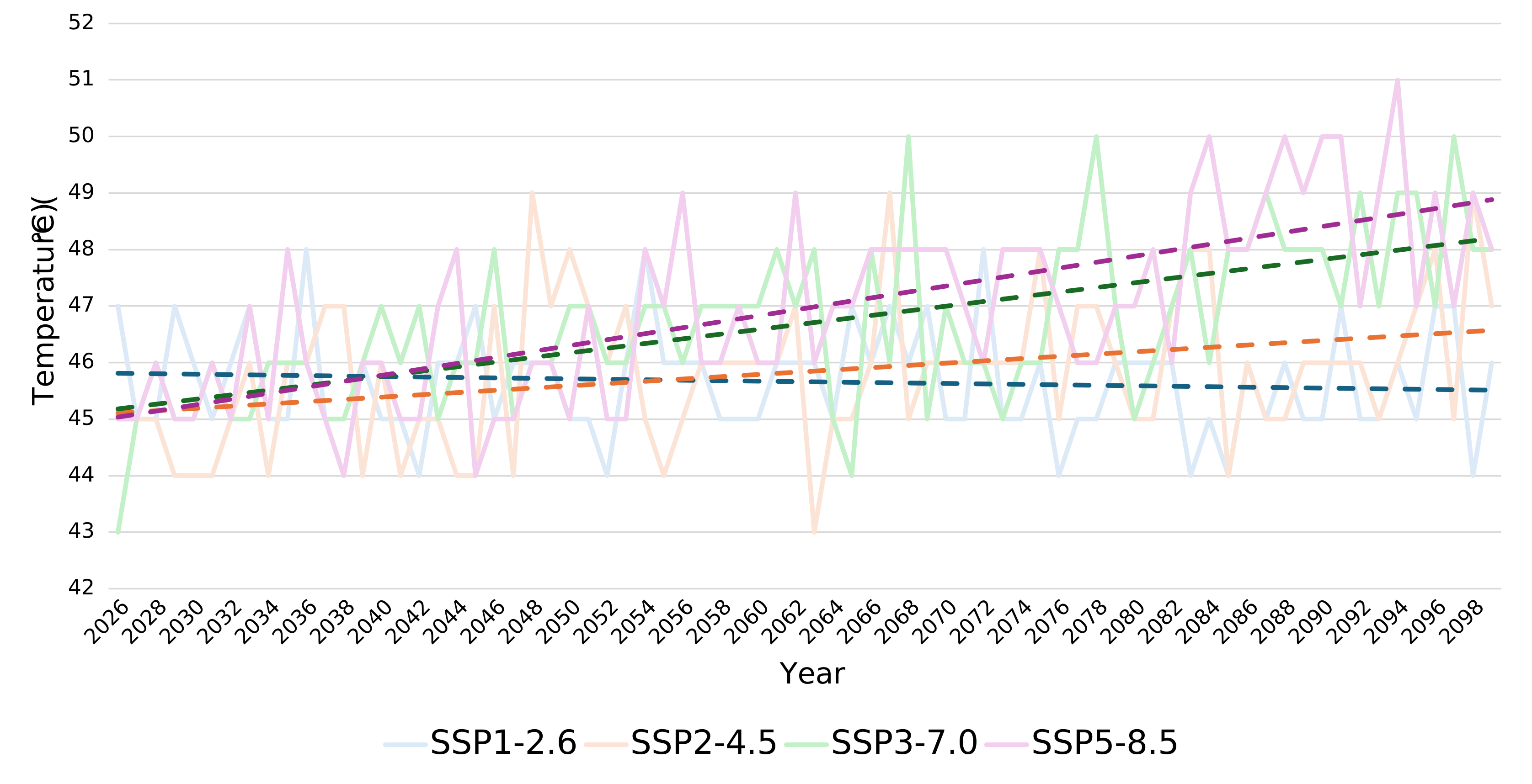
Figure 4 illustrates projected annual maximum near‑surface air temperature for a representative Mojave Desert location under four CMIP6 scenarios (SSP1‑2.6, SSP2‑4.5, SSP3‑7.0, and SSP5‑8.5), highlighting increasing scenario divergence—and uncertainty—over time.
Mojave Desert, 2026–2099
- Daily outputs and monthly or annual aggregates for long‑term trend analysis and scenario comparison
- Hourly downscaled time series for PV models requiring hourly or 8760‑format inputs
- Projected Temperature‑Weighted Year (8760), an industry‑first file type applying a temperature‑weighted typical‑year methodology over a user‑defined future period, compatible with common PV design tools
These design choices ensure CMIP6 climate projections can be applied consistently across yield analysis, performance modeling and long‑term risk assessment—without requiring changes to existing workflows.
Quantifying wildfire smoke impacts on irradiance
Wildfire smoke has emerged as a material and growing risk factor for solar performance in many regions. Smoke aerosols attenuate surface irradiance, affecting both short‑term operations and long‑term historical performance analysis.
SolarAnywhere MeteoLens introduces explicit quantification of smoke‑impacted irradiance, enabling users to identify when and where wildfire smoke has influenced solar resource availability. This capability supports:
- More accurate historical performance analysis
- Improved diagnostics for unexplained production losses
- Clearer separation of meteorological variability from operational issues
The Clean Power Research team has studied wildfire smoke impacts on solar resource availability for many years, including peer‑reviewed publications such as Quantifying the Solar Impacts of Wildfire Smoke in Western North America (2021) and Quantifying the Effects of the 2023 Canada Wildfires on Surface Solar Irradiance (2025). These studies demonstrate that smoke impacts can be both severe and geographically widespread.
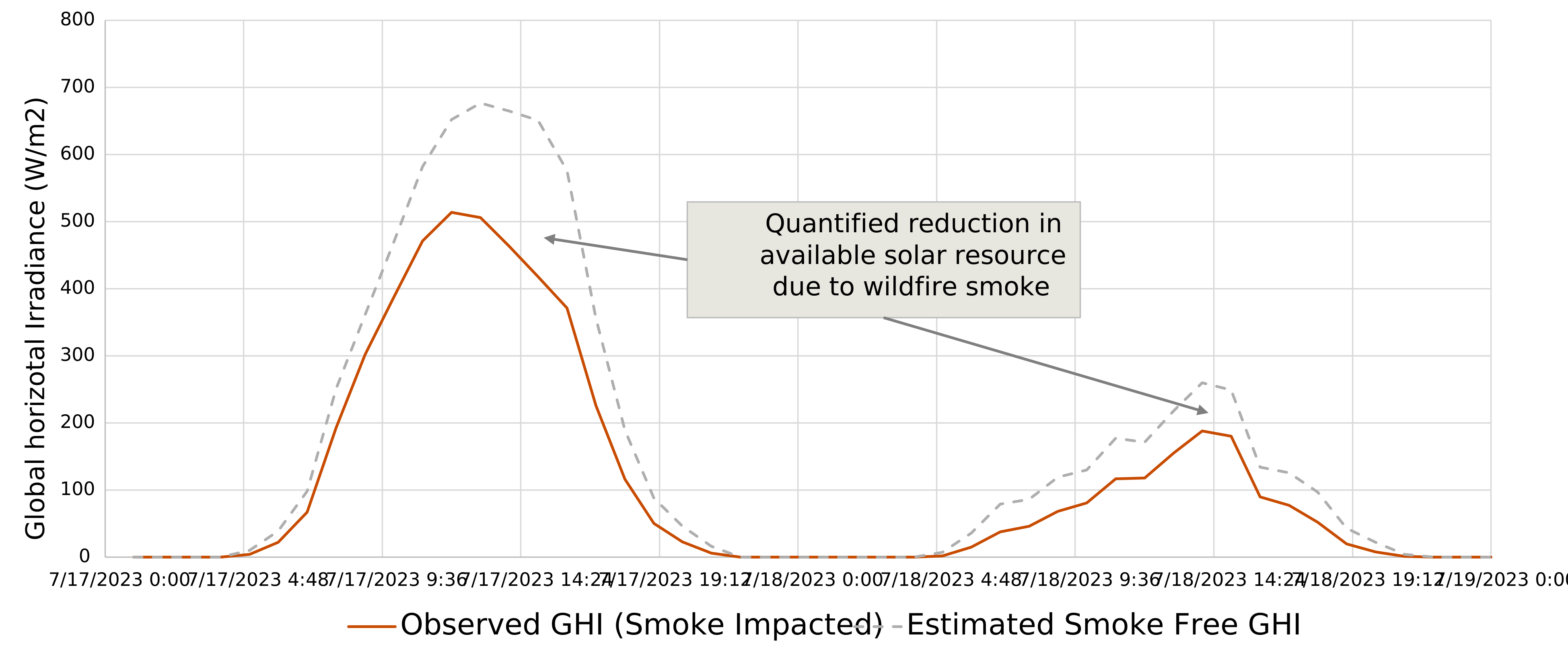
Figure 5 illustrates the impact of wildfire smoke on solar irradiance using a real-world example from Alberta during the 2023 wildfire season. The comparison between observed conditions and estimated smoke free irradiance highlights the magnitude and timing of smoke-related reductions in available solar resource.
Alberta, July 2023
Objectivity as a core Clean Power Research principle
At Clean Power Research, objectivity is a foundational principle that guides how we develop and deliver data to the solar industry. Solar resource uncertainty plays a critical role in project development and financing, and our focus remains on delivering independently developed, scientifically grounded datasets that can be trusted globally across a wide range of applications and analytical frameworks.
By remaining agnostic and independent of downstream tools, processes and implementation choices, SolarAnywhere is uniquely positioned to serve the full ecosystem of developers, operators, lenders, engineers, insurers and analysts. This approach supports consistent, unbiased evaluation of solar resource and risk—allowing stakeholders to apply SolarAnywhere data confidently within their own preferred workflows and decision‑making contexts.
Looking ahead
SolarAnywhere Data Version 4.1 and the MeteoLens license reflect a broader evolution in how solar risk is evaluated—moving beyond purely historical perspectives toward integrated, lifetime‑aware analysis that accounts for changing climate conditions, extreme events and long‑term uncertainty.
As the industry continues to adapt to these challenges, Clean Power Research remains committed to delivering accurate, transparent and decision‑relevant datasets that empower confidence at every stage of a project’s lifecycle.
Get started today
Log in to the SolarAnywhere Data Portal to explore Data Version 4.1 and MeteoLens. If you don’t already have a SolarAnywhere account, you can sign up to access select V4.1 and MeteoLens datasets at no cost.
Feedback is always appreciated—please don’t hesitate to share input directly through the data portal or contact our team!