In February 2018, we blogged about the future of solar forecasting with the new NOAA/NASA GOES-16 satellite. The launch of the GOES-17 satellite held similar promise, but bringing it online ended up being problematic for NOAA/NASA—and provided a few wrinkles for those using the satellite data.
Today we share the GOES-17 story and how SolarAnywhere® customers are now benefitting from the enhanced imagery it provides.
Satellite images feed SolarAnywhere data
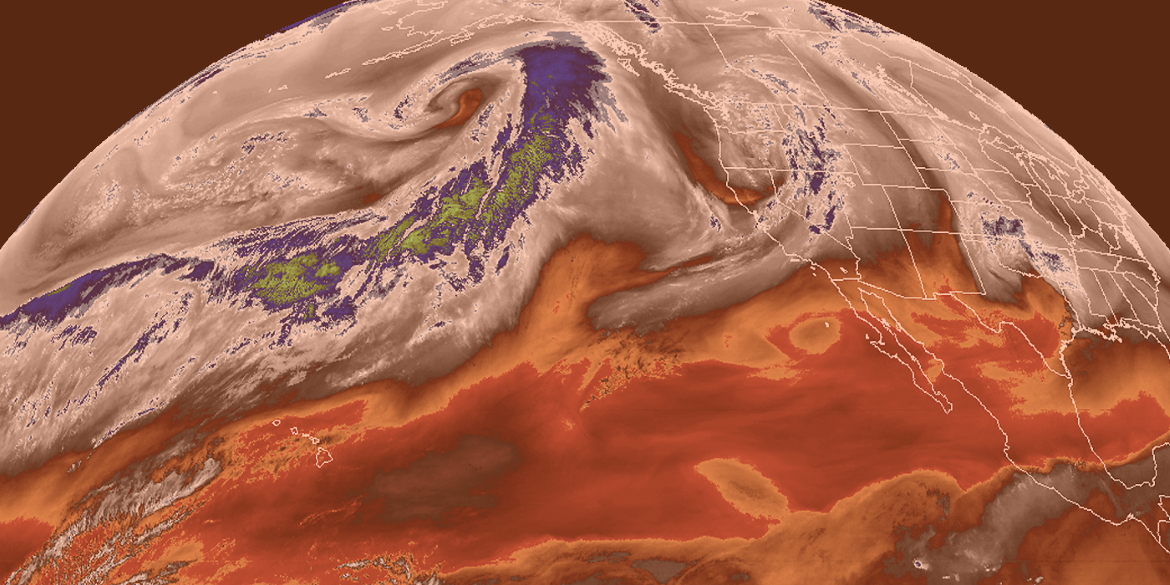
There are two operational satellites covering North and South America at any time, one for the East region (GOES-East, AKA GOES-16) and one for the West (GOES-West, AKA GOES-17). Together, GOES-16 and GOES-17 give weather and climate scientists’ access to new and higher resolution data throughout the Western hemisphere.
SolarAnywhere uses visible and infrared (IR) image inputs from both satellites to measure and forecast solar irradiance. Image quality and reliability have an impact on SolarAnywhere. Building a robust software platform around these inputs is key to delivering quality and reliability to SolarAnywhere users.
Bringing GOES-17 online
GOES-17 was scheduled to become the operational GOES-West satellite in 2018, replacing GOES-15. However, a problem with GOES-17 was discovered two months after launch. Data from the infrared (IR) channels were badly degraded due to a malfunction of the satellite cooling system. Heat from solar radiation hitting the satellite at certain times of day interfered with the operation of the satellite’s main sensor. The success of the multi-billion-dollar program was in limbo as project engineers searched for solutions.
Thankfully that effort was successful. After 10 months, in February 2019 , GOES-17 was declared the operational GOES-West satellite. (The story about how engineers from NOAA, Harris Corp. and other companies saved GOES-17 is a great read.)
According to GOES-17 project engineers, the main sensor will provide 97% of the intended data over the course of a year. That still leaves three percent of the data unusable, and some portion degraded. To give users time to assess and transition to the new satellite, NOAA/NASA kept GOES-15 running in parallel through January 2020.
Delivering quality SolarAnywhere Data with GOES-17
It would be easy to call 3% negligible and move on. But for customers that trust SolarAnywhere to provide the most accurate solar data and forecasts, a few percent can have significant financial consequences. With that in mind, our team worked to assess and mitigate the impact of the GOES-17 malfunction to our customers.
SolarAnywhere utilizes infrared data in two main ways. First, to distinguish between snow and clouds, both of which show up as white in visible light. Second, for pre-dawn forecasts where infrared is used to track cloud motion before the sun is up.
Degradation of the IR data depends on how the sun hits the satellite, which is a function of several orbits and the orientation of the satellite itself. That means the timing of the degradation is predictable. Peak saturation is estimated to occur on February 26, April 13, August 30 and October 16 at approximately 13:00 UTC. That translates to 5 a.m. Pacific Time during the shoulder seasons, exactly when pre-dawn forecasts are necessary to predict the impact of solar on the western power grid.
Having narrowed in on the problem, we tested forecast accuracy using a range of model inputs and calibrations. These included combinations of IR bands (there are six, some of which are more sensitive to overheating depending on the portion of the electromagnetic spectrum they cover) and quality control flags. Through these efforts, we’ve been able to keep GOES-17 based pre-dawn forecasts on par with those generated from GOES-15.
We also looked at historical irradiance accuracy, and here we have great results to share. SolarAnywhere irradiance derived from GOES-17 is consistently more accurate than ever before. We suspected this might be the case because improved navigation reduces jitter on the new generation of satellites, similar to improvements we saw with GOES-16, as shown in Figure 1.
Figure 1: Comparison of GOES-13 and GOES-16


Image loops for same location and time from GOES-16 (Right) and its predecessor, GOES-13 (Left) display the improved stability of the newer satellites
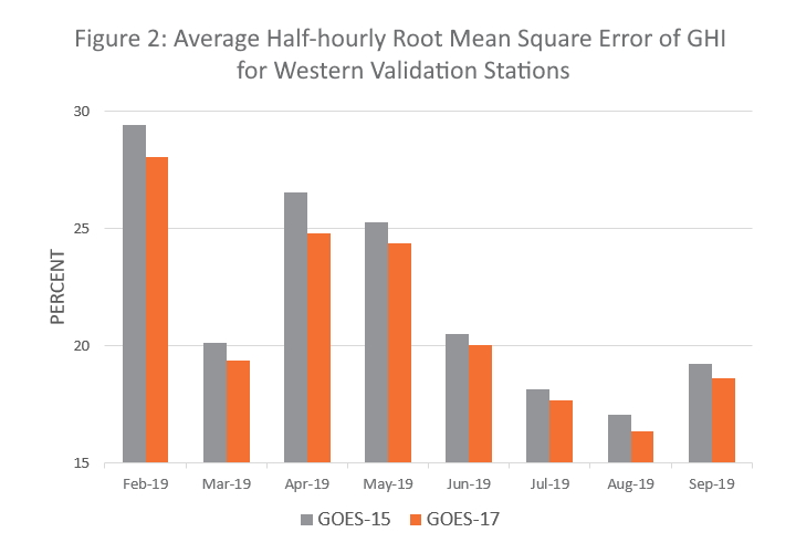
Now we can prove it. Figure 2 shows the results of an analysis of six Western U.S. reference stations over a period of eight months. The analysis revealed that the half-hourly root-mean-square error of SolarAnywhere GHI GOES-17 derived data was four percent lower than GOES-15 derived data.
Due diligence complete, we seamlessly transitioned all operational SolarAnywhere services for the GOES-West region to GOES-17 on December 2, 2019. Seamless is the key word here—SolarAnywhere now serves customers managing 10+ GW of operating solar projects, 20+ million annual API calls and on-demand data updated to current day through our website. The only thing these customers will see from the GOES-17 infrared sensor saga is more accurate data.
If you have questions about our operational data services, please contact us.